The Meteorology, Climatology and Geophysics Agency (BMKG) issued a tsunami warning on Wednesday, July 30, 2025 following a powerful magnitude-8.7 undersea earthquake that struck off the eastern coast of Kamchatka Peninsula, Russia, earlier in the day.
The quake, which occurred at a depth of 18 kilometers due to subduction activity in the Kurile-Kamchatka Trench, has triggered regional and international concern over potential tsunami threats across parts of the Pacific, including Indonesia.
BMKG Earthquake and Tsunami Center Director, Daryono, said in a statement from Jakarta that the agency’s analysis indicated the quake could generate tsunami waves with alert-level height less than 0.5 meters in several coastal areas across eastern Indonesia.
“Communities in the affected coastal areas are advised to stay calm, stay away from the shoreline, and await official updates,” Daryono said.
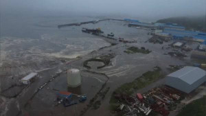
So far, no reports of damage or casualties have been recorded in Indonesian territory as a result of the quake.
Daryono added that as of 8:30 a.m. Western Indonesia Time (WIB), BMKG had detected at least seven aftershocks in the region, with magnitudes ranging from 5.4 to 6.9.
The Pacific Tsunami Warning Center (PTWC) has also issued alerts for potential tsunami impacts in Russia, Japan, Alaska, the Philippines, Hawaii, and Guam.
Pacific Islands on high alert
Several Pacific island governments have issued evacuation orders and tsunami warnings in response to the Russian quake.
In Guam, the Homeland Security and Civil Defense Office warned of significant threat levels to Guam, Rota, Tinian, and Saipan, citing possible hazardous sea level fluctuations and strong ocean currents.
“Waves could arrive as early as 2:30 p.m. AEST,” the agency said. Residents were urged to move at least 30 meters inland and seek higher ground 15 meters above sea level.
American Samoa is also bracing for waves of up to 3 meters, expected to arrive at around 9:39 p.m. local time, according to U.S. meteorological agencies.
Other affected regions issuing similar tsunami alerts include, Palau (0.3–1 meter wave height, arrival at 3:19 p.m. local time, Tonga (0.3–1 meter, ETA 9:25 p.m.).
Meanwhile, Fiji, Kiribati, Nauru, New Caledonia, Solomon Islands, Tuvalu, Vanuatu, Marshall Islands, and Jarvis Island, all expecting waves ranging from 0.3 to 1 meter.
BMKG reiterated its call for Indonesians to rely only on official information channels and not to be influenced by unverified reports circulating online. The agency continues to monitor seismic activity and ocean conditions in real-time.
According to BMKG data, areas under tsunami alert status include:
•Talaud Islands (ETA: 14:52:24 Central Indonesia Time or WITA)
•Gorontalo City (16:39:54 WITA)
•North Halmahera (16:04:24 Eastern Indonesia Time or WIT)
•Manokwari (16:08:54 WIT)
•Raja Ampat (16:18:54 WIT)
•Biak Numfor (16:21:54 WIT)
•Supiori (16:21:54 WIT)
•Sorong (North) (16:24:54 WIT)
•Jayapura (16:30:24 WIT)
•Sarmi (16:30:24 WIT)
Authorities across the Pacific region remain on high alert as aftershocks and sea-level anomalies continue to develop throughout the day.
Already have an account? Sign In
-
Start reading
Freemium
-
Monthly Subscription
20% OFF$29.75
$37.19/MonthCancel anytime
This offer is open to all new subscribers!
Subscribe now -
Yearly Subscription
33% OFF$228.13
$340.5/YearCancel anytime
This offer is open to all new subscribers!
Subscribe now
Set up email notifications for these topics